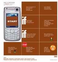
Mazhar's Digital Reading Map
Here it is, the final project. From the beginning, my cell phone has been the tool for Virtual Community class projects. So i could not afford to avoid it for the final proj too. Cell phone is more my assistant in life. it notifies me important dates and times, organises my contacts, quick notes and many more. I think a pda like cell phone such as Nokia 6680 (Nokia 6670 - similar feature phone in Canada from the doggy Fido) can be really handy.
When i drive to a new location, i get the route map from google and save it on TextEdit or Illustrator and export as PDF. Then i transfer the pdf on the phone via bluetooth and view as full screen on phone. Thats all i need. No prints, no remembering. As i cross each direction steps, all i have to do is hit the down arrown key and scroll down. makes life more digitally easy.
Thanks to Nokia, Apple, Bluetooth, Adobe. Life is really getting digital as long as you keep the freezing and overheating Microsoft away. But hence we are all going lazy too.
 Anyways, for this class, i have converted my flowchart style map into slideshow to be displayed on phone.
its a more custom. it could be more practical too if we were to make a template for indesign and then export as pdf, transfer via bluetooth. I think that would require indesign knowledge, for those who dont, a software could be programmed or a webpage where it will create pdf automatically, there r some pluginns for webprogrammers in the market tat facilitates this option.
Though my image example post is based on my flowchart map posted earlier, It could be made more easy with actual directions. Once user requests driving directions on google map or mapquest or yahoo, an option could be made where by user could download as pdf slide for cell phones. Similar to print now feature which opens a new window with same content with less graphics. Bluetooth is already a standard feature on all phones and computers now, so i really believe this could be an handy feature. How many can afford a gps system on their cars... so this is economically (or freely) practical.
In between - the same could be applied on other new models from motorola, samsung with pdf support. unfortunatly north america are beind europe and asia in mobile tehnology. if we were competent with other locations... we could have used the phone to access map website and auto download the pdf which would avoid the steps of indesing, computer and bluetooth transfer. but hey, they are only few months away from being practical. lets cross our fingers and hope somebody does it, call google.
Mazhar Mohad

2 Comments:
Love the PDF idea - however, I also think that people might get lost in the "IF' type instructions. What if you lose track of where you are? How to get an overview again? I hope you'll explain this in more detail in class today, because it will really help me to sort out how to refine this into a clear and simple "recipe".
well the IF was only because it was transformed from the original idea. it was more there for fun. But in reality, i intend it to be clear and specific. each page of the pdf describing "just" "drive straight take left at abcd street"
Post a Comment
<< Home